
Drilling, Construction and Testing of Monitor Wells for the Edwards Aquifer Bad Water Line Experiment
| Author | William F Guyton Associates, Inc (for City Water Board of San Antonio, Edwards Underground Water District, Texas Water Development Board, US Geological Survey) |
| Year | 1986 |
| Description | Study of the fresh water-saline interface using new monitoring wells in the San Antonio Artesia Water Field. Note: This report is included for its historical value and may no longer reflect current conditions. |
| Publisher | William F Guyton Associates, Inc |
| Location | Edwards Aquifer, Balcones Fault Zone, San Antonio Segment, Artesia Well Field |
| Cover | View Download |
| File | View Download |
| Summary |
|
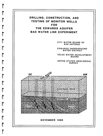
Note: This report is included for its historical value and may no longer reflect current conditions. The primary purpose for the Edwards aquifer bad water line experiment is to establish a long-term monitoring system and develop site-specific information at one location along the bad water line. Ongoing analysis of information obtained as a result of this project is expected to help in determining whether encroachment of poor quality water presents a serious problem to maximum use of the aquifer as natural and man-made stresses of the aquifer come to pass, and in determining ways to avoid the problem to the extent it exists. This report discusses the drilling, construction, and testing of monitor wells along a transect of the Edwards aquifer bad water line and the data that were obtained during those operations. The transect is the first of a number of similar transects that are planned for various locations along the bad water line of the Edwards aquifer in the San Antonio region. It is located near the City Water Board of San Antonio’s Artesia Well Field in the eastern part of San Antonio, Texas. Seven monitor wells were constructed during this part of the Edwards aquifer bad water line experiment. The wells are completed at different depths in the Edwards aquifer at three sites along the transect. Three wells are located at the bad-water zone site, the southernmost site, two are located at the transition-zone site, and two are located at the fresh-water zone site, which is adjacent to the Artesia Well Field and a little more than a mile north-northwest of the bad-water zone site. … The U.S. Geological Survey through a cooperative program with the City Water Board and the Edwards Underground Water District is currently making a more detailed analysis of conditions along the transect. This analysis will include microscopic examination of drill cutting samples and detailed study of geophysical logs, bore hole surveys, and geochemistry. Long-term monitoring of water levels and water quality will provide information for determining whether the bad water line shifts as a result of stresses imposed on the aquifer, and if so, how this is likely to affect the availability of fresh ground water. In view of the presence of poor quality water in the lower part of the Edwards aquifer at the northernmost drilling site, it will be desirable to extend the transect northward into and beyond the Artesia Well Field to find out if poor quality water is present in the lower part of the aquifer in a much larger part of the area. Construction of additional monitor well transects of the Edwards aquifer bad water line will be needed in other areas to better establish how conditions along the bad water line are likely to affect the availability of fresh ground water from the aquifer on a regional basis. Consideration needs to be given to constructing a transect of the bad water line in the New Braunfels or San Marcos areas to the north, and another one in the D’Hanis or Uvalde areas to the west. The bad water line in the areas to the north may be related to faulting, whereas in the areas to the west, it may be related to rock permeabilities. These areas are in or near major groundwater flow paths. Therefore, the information obtained from these transects also will contribute to a better understanding of regional hydrology. |
Search for Documents
Advance Search
Explore EAA's Scientific Reports
- All Reports
- Remote Sensing
- Precipitation
- Overview Studies
- Modeling
- Hydrology and Hydrogeology
- History
- Groundwater Recharge, Recharge Zone
- Groundwater Movement
- Geomorphology and Caves
- Weather Modification
- Geology
- Water Use and Conservation
- Geochemistry
- Water Resources Planning and Management
- Floods and Drought
- Water Quality
- Climatology
- Surface Water / Groundwater Relationship
- Biology
- Springs, Groundwater Discharge
- Archaeology
- RZ Protection
- Aquifer Levels