
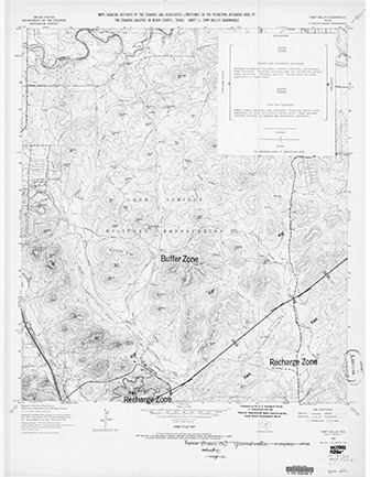
Maps Showing Outcrops of the Edwards and Associated Limestones in the Principal Recharge Area of the Edwards Aquifer in Bexar County, Texas [6 maps]
| Author | US Geological Survey, Edwards Underground Water District, Texas Water Development Board |
| Year | 1965 |
| Description | Six topographic maps of the Edwards Aquifer Recharge Zone, scale 1:24,000. Camp Bullis Quadrangle, Bulverde Quadrangle, Helotes Quadrangle, Longhorn Quadrangle, Castle Hills Quadrangle, San Geronimo Quadrangle. Note: Both letter-size and full-size maps are included. |
| Report Number | USGS Open File Maps AMS 6243 11 NE-SERIES V882 1965, AMS 6343 Ill NW - SERIES V882 1967, AMS 6243 II SW-SERIES V882 1966, N 2930 |
| Publisher | US Geological Survey |
| Location | Edwards Aquifer Balcones Fault Zone San Antonio Segment, Recharge Zone, Bexar County |
| Cover | View Download |
| File | View Download |
| Summary |
|
Six topographic maps of the Edwards Aquifer San Antonio region, scale 1:24,000. Camp Bullis Quadrangle, Bulverde Quadrangle, Helotes Quadrangle, Longhorn Quadrangle, Castle Hills Quadrangle, San Geronimo Quadrangle. Note: Both letter-size and full-size maps are included. |
Search for Documents
Advance Search
Explore EAA's Scientific Reports
- All Reports
- Water Quality
- Climatology
- Surface Water / Groundwater Relationship
- Biology
- Springs, Groundwater Discharge
- Archaeology
- RZ Protection
- Aquifer Levels
- Remote Sensing
- Precipitation
- Overview Studies
- Modeling
- Hydrology and Hydrogeology
- History
- Groundwater Recharge, Recharge Zone
- Groundwater Movement
- Geomorphology and Caves
- Weather Modification
- Geology
- Water Use and Conservation
- Geochemistry
- Water Resources Planning and Management
- Floods and Drought