
Water resources of the Edwards Aquifer Region [Infographic]
| Author | Edwards Underground Water District |
| Year | 1987 |
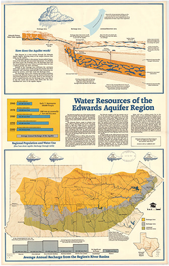
| Description | Infographic and map showing structure, discharge and recharge of the Edwards Aquifer. Scale ca. 1:500,000. Note: contains both letter-size and large-format versions. |
| Publisher | Edwards Underground Water District |
| Location | Edwards Aquifer |
| Cover | View Download |
| File | View Download |
| Summary |
|
Infographic and map showing structure, discharge and recharge of the Edwards Aquifer. Scale ca. 1:500,000. |
Search for Documents
Advance Search
Explore EAA's Scientific Reports
- All Reports
- Weather Modification
- Geology
- Water Use and Conservation
- Geochemistry
- Water Resources Planning and Management
- Floods and Drought
- Water Quality
- Climatology
- Surface Water / Groundwater Relationship
- Biology
- Springs, Groundwater Discharge
- Archaeology
- RZ Protection
- Aquifer Levels
- Remote Sensing
- Precipitation
- Overview Studies
- Modeling
- Hydrology and Hydrogeology
- History
- Groundwater Recharge, Recharge Zone
- Groundwater Movement
- Geomorphology and Caves