
 Aquifer Conditions
Science & Data Document Library
Science and Data Resources
Survey Report on Edwards Underground Reservoir Guadalupe, San Antonio and Nueces Rivers and Tributaries, Texas. Volume 1 Main Report
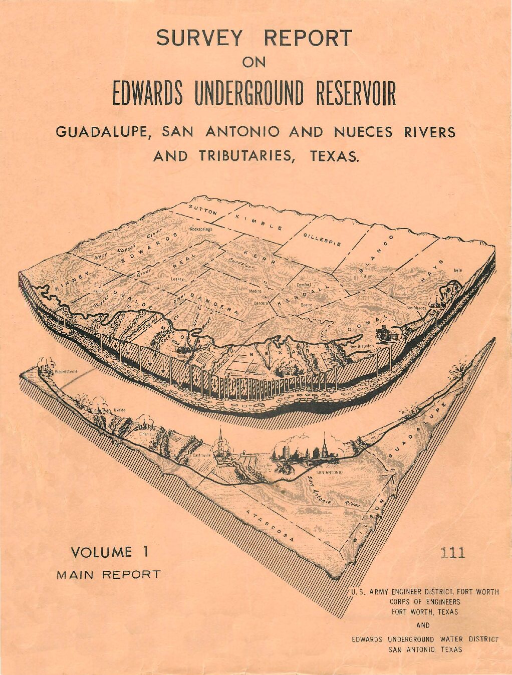
Description: Note: This report is included for its historical value and may have been replaced by more recent studies. Volume 1 of survey by the US Army Corps of Engineers and the Edwards Underground Water District, emphasizing possible locations for reservoirs and containment systems.
Location: Edwards Aquifer, Guadalupe River, San Antonio River, Nueces River
Summary:Note: This report is included for its historical value and may have been replaced by more recent studies. Volume 1 of survey by the US Army Corps of Engineers and the Edwards Underground Water District, emphasizing possible locations for reservoirs and containment systems.
Phase I Edwards Underground Water District Storage-Release Recharge Facility Evaluation
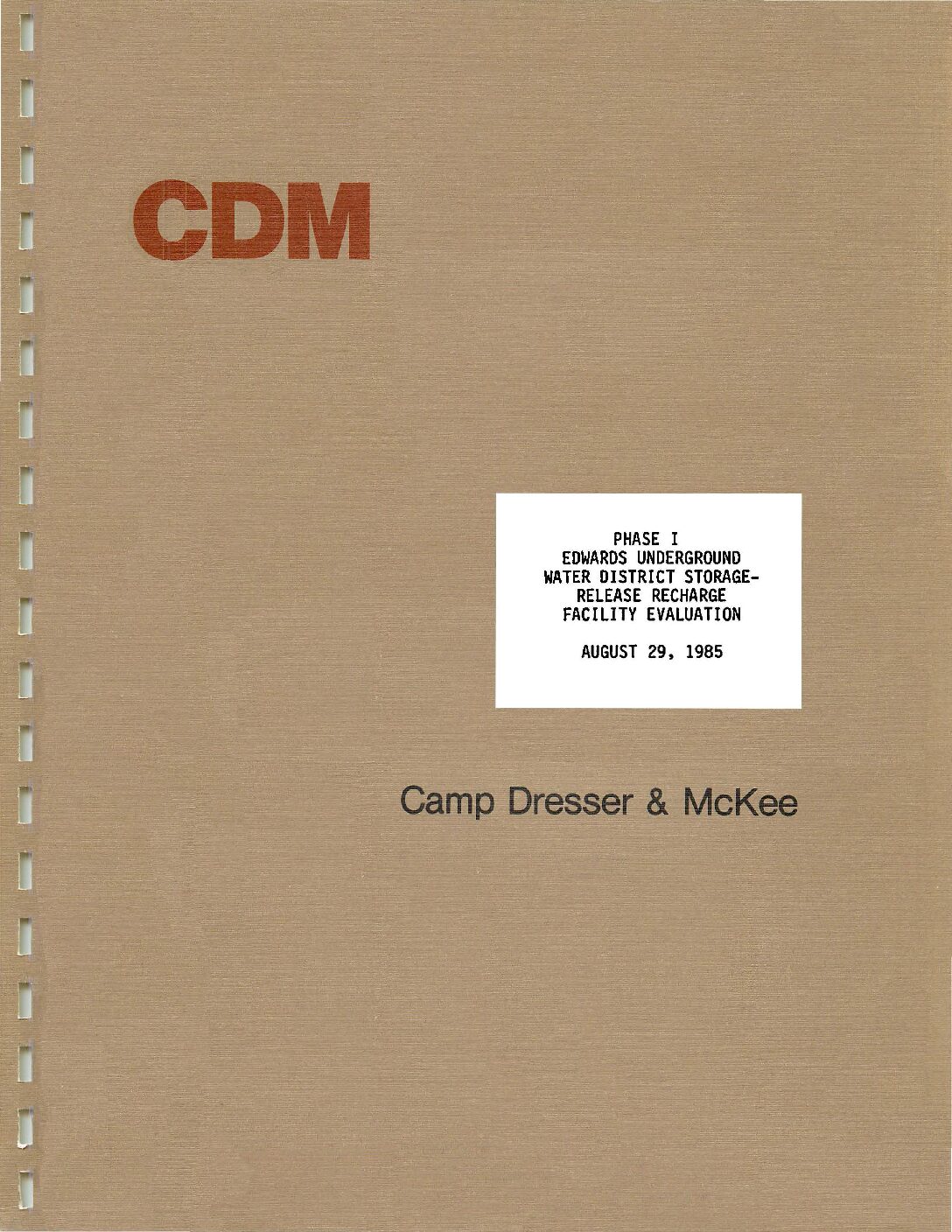
Description: Engineering and simulation study to evaluate two potential sites for storage/release reservoirs on the Frio and Dry Frio Rivers. Note: This report is included for its historical value and may have been replaced by more recent studies.
Summary:Engineering and simulation study to evaluate two potential sites for storage/release reservoirs on the Frio and Dry Frio Rivers.
Note: This report is included for its historical value and may have been replaced by more recent studies.
South Central Texas Regional Water Planning Area 2001 Regional Water Plan Volume I Executive Summary and Regional Water Plan-Part 2
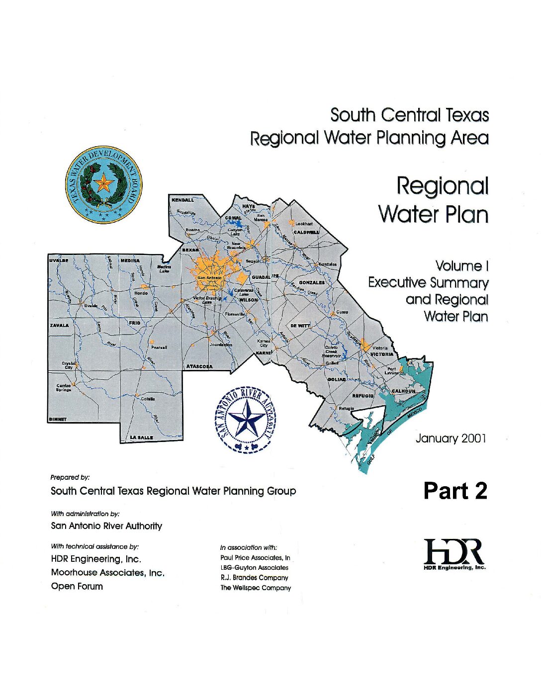
Description: Executive Summary and Water Plan for the 2001 South Central Texas Regional Water Plan Part 2. Note: This report is included for its historical value but was replaced by the 2006 South Central Texas Regional Water Plan, the 2011 South Central Texas Regional Water Plan, and eventually by the Texas Water Plan.
Location: South Central Texas
Summary:Note: This report is included because of its historical value and has been replaced by the Texas Water Plan. It covers in part the jurisdiction of the Edwards Aquifer Authority.
Table of Contents (Parts 1 and 2):
Executive Summary
- Description of Region
- Population and Water Demand Projections
- Evaluation of Current Water Supplies
- Comparison of Supply and Demand
- Regional, County, City, Water User Group, and Major Water Provider Plans
- Additional Recommendations/Conservatoin Guidelines
- Plan Adoption
Appendices
- Irrigation Projection Methodology
- General Procedures and Assumptions for Technical Evaluations
- Reliability Information for Water Rights in the South/Central Texas Region
South Central Texas Region 2000 Water Needs Assessment
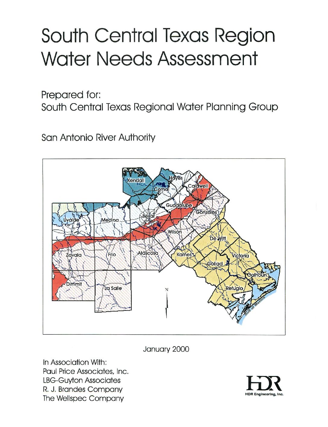
Description: Note: This report is included for historical value but has been replaced by the Texas Water Plan. Summaries of various sources of water, their costs, and projected needs of each county and jurisdiction by use.
Location: South Central Texas
Summary:This report is included for historical value but has been replaced by the Texas Water Plan. This is a series of graphical presentations of possible sources of water and their costs, along with projected needs of each county and jurisdiction through 2050. It covers in part the area served by the Edwards Aquifer Authority.
Trans-Texas Water Program West Central Study Area Integrated Resource Planning Committee Final Criteria Report Public Participation / Stakeholder Involvement Process
Description: Note: This report is included because of its possible historical value. It has been replaced by more recent plans. Input of public and stakeholders in the Trans-Texas Water Program West Central Study Area.
Location: West Central Texas
Summary:Note: This report is included because of its possible historical value. It has been replaced by more recent plans.
The Trans-Texas Water Program was initiated as a regional water planning process by the Texas Water Development Board to identify the most cost-effective and environmentally sensitive strategies for meeting the current and future water needs of southeast, south-central, west-central and north-central Texas. Each of these areas was designated as a study region. This report relates to the West Central Study Area of the Trans-Texas Water Program which was formed in 1993 (see map of study region, p. 3.). The West Central Study Area comprises thirty-two (32) counties west of the Brazos River and includes the Guadalupe-Blanco, San Antonio and Lower Colorado River basins, part of the Nueces River basin, the Edwards Aquifer and part of the Carrizo-Wilcox Aquifer.
Initially, the program was to be carried out in three phases: 1) Program Initiation/Conceptual Planning; 2) Feasibility Studies; and 3) Implementation. The Senate Bill 1 process superseded the Trans-Texas Water Program process and consequently, feasibility studies and the implementation phases were not completed.
Committee Conclusions
Water Resource Evaluation Criteria
The Water Resource Evaluation Criteria listed below were the result of the deliberations of the Integrated Resource Planning Committee over the period of its existence. As agreed to by the committee and the PMC for the West Central Study Area, these criteria will be submitted to the Texas Water Development Board as part of the record of work accomplished by the Trans-Texas Water Program for this study area. They are intended for use by water planners as they evaluate the various alternatives to meet the water needs of their region. The criteria would be employed by asking how well an alternative achieves the following objectives:
Economic
*Facilitates economic development
*Minimizes long range negative socio-economic impacts (including loss of tax base)
*Promotes opportunities for cost sharing and economic partnership
*Provides cost effective solutions
Water Quality
*Provides and maintains appropriate water quality for the intended use
Fairness
*Maximizes efficient use of water in areas that import water
*Promotes equitable distribution of costs in meeting region's water needs
Feasibility
*Demonstrates feasibility in terms of timing, technical, scientific, economic, political, regulatory, legal, and public acceptance factors
Efficiency
*Minimizes evaporative and distribution losses
*Promotes conservation
*Promotes conjunctive use
Flexibility
*Adaptable to new and innovative technology
*Adaptable to changes in demand projections
*Adaptable to changes in law
*Adaptable to future supply options
Compatibility
*Maximizes regional compatibility with local water plans
*Minimizes negative impacts on property rights
*Maximizes consistency with local growth management plans
*Maximizes compatibility with plans from surrounding regions
Reliability
*Maximizes a sustainable (referring to yield) supply of water for short-term and long-term needs
*Minimizes interruptions to water supplies
Environment
*Minimizes short-term and long-term negative impacts on natural resources
¢Wildlife/habitat
*Rivers
*Bays
¢ Estuaries
¢ Lakes
*Aquifers
*Karsts
*Air quality
*Water quality
¢ Wetlands
*Minimizes short-term and long-term negative impacts to the human environment
*Recreational
*Cultural/historical
*Archeological
¢ Esthetics
Recommendations
The IRPC agreed on the following recommendations with the intention of providing more guidance to water planners to assure better regional water planning. The IR.PC wanted to emphasize the need for water planners to take into account the indirect impact of their actions and decisions as well as their direct impact. The recommendations were:
*Public participation and education should continue to be an integral part of a regional water planning process.
*When evaluating alternatives, ensure that indirect impacts such as growth inducing or inhibiting effects are considered.
Trans-Texas Water Program West Central Study Area Public Participation / Stakeholder Involvement Plan
Description: Note: This report is included because of its possible historical value. It has been replaced by more recent plans. Plan for involving the public and stakeholders in the planning process for the Trans-Texas Water Program West Central Study Area
Location: West Central Texas
Summary:Note: This report is included because of its possible historical value. It has been replaced by more recent plans.
The purpose of this document is to submit to the Policy Management Committee (PMC a recommendation for a design and implementation of the public participation / stakeholder involvement plan. This recommendation is the result of the first phase of analysis and data gathering and is designed to capitalize on what has been teamed from and about the public, stakeholders, and sponsoring agencies.
The public participation plan recommended here is a comprehensive approach designed to work in partnership with each of the sponsor agencies, the advisory committees, the technical contractor, and the public. The goal of the public participation plan is to work within this partnership providing input to the PMC in the fulfillment of their mission, which is: To develop a menu of regional water resource planning strategies which are both technically feasible and publicly acceptable, and which meets the future water needs of the entire 32 county study region.
It is recognized that public participation and input is an integral part of the Trans-Texas Water Program effort and that the conclusion of the program, as mentioned above, is a menu of strategies from which the regional participants would be encouraged to select strategies which best meet their individual local needs.
The design of the public participation plan is based upon input from the public, stakeholders, and water agencies (including the sponsor agencies) which was gathered in phase one. A large quantity of information has been assembled and analyzed, resulting in the following key findings used in the plan design:
*Residents chose having a reliable supply as the highest priority, followed closely by water quality and more distantly by keeping the cost of water low.
*One-third of the region's residents are not concemed about future water shortages.
*Conservation is most often mentioned as the single most important thing to do to ensure water for the future, and is the most well known and supported water management strategy.
*Except for conservation, citizens are generally not familiar with other water supply options.
*One-third of the residents do not feel they are informed on water issues.
*Residents want to be kept informed on water issues.
*When seeking reliable information on water issues, three-fourths of the residents turn to either their local water/utility department, city or county government, water districts or authority.
*Residents most frequently state they trust elected local/state officials and local water officials to make decisions about meeting future water needs, however one-third either trust nobody or do not know who to trust.
The recommended plan is designed to address the issues as well as the opportunities which exist throughout the study region within the framework set forth above[:]
*Three-quarters of residents in the study region strongly agree that elected and water utility officials should involve the public in water planning issues.
¢ Integrated Resource Planning Workshop (Task 4-1)
¢ Elected and Water Officials Briefings/Updates (Task 4.2)
¢ Implementation of Media Plan (Task 4-3)
¢ Assist in Development of Phase 2 Technical Scope of Work (Task 4-4)
¢ Define and Implement IRP Organizational Requirements with Sponsor Agencies (Task 4-5)
¢ Identify Planning Policy Objectives With Each Sponsor Agency (Task 4-6)
¢ Re-Structure of Advisory Committees (Task 4-7)
¢ Advisory Committee Meetings (Task 4-8)
¢ Informational Materials Development and Production (Task 4-9)
¢ Materials Distribution (Task 4-10)
¢ Develop Public Information and Involvement Opportunities Through Outreach Efforts (Task 4-11 )
¢ Refine and Expand the Public's Evaluation Criteria (Task 4-12)
¢ Advisory Committee's Interim IRP Report (Task 4-13)
¢ Coordinate With Technical Contractor to Evaluate Resource Options (Task 4-14
¢ Assist in Characterizing Resource Options (Task 4-15)
¢ Identify and Define Future Uncertainties and Potential Outcomes (Task 4-16)
¢ Selection of Water Resource Scenarios (Task 4-17)
¢ Advisory Committee's Final IRP Report (Task 4-18)
South Central Texas Regional Water Planning Area 2001 Regional Water Plan Volume II Technical Evaluations of Alternative Regional Water Plans
Description: Volume II of three volumes of the 2001 South Central Texas Regional Water Plan. Note: This report is included for its historical value but was replaced by the 2006 South Central Texas Regional Water Plan, the 2011 South Central Texas Regional Water Plan, and eventually by the Texas Water Plan.
Location: South Central Texas
Summary:Table of Contents of Volume II:
- Introduction
- Planning Unit (PU) Alternative
- Environmental/Conservation Alternative
- Economic/Reliability/Environmental/Public Acceptance (EREPA) Alternative
- Inter-Regional Cooperation (IRC) Alternative
- Recharge & Recirculation (R&R) Alternative
- General Comparisons
- Environmental Assessment and Comparisons
South Central Texas Regional Water Planning Area 2001 Regional Water Plan Volume I Executive Summary and Regional Water Plan-Part 1
Description: Executive Summary and Water Plan for the 2001 South Central Texas Regional Water Plan Part 1. Note: This report is included for its historical value but was replaced by the 2006 South Central Texas Regional Water Plan, the 2011 South Central Texas Regional Water Plan, and eventually by the Texas Water Plan.
Location: South Central Texas
Summary:Note: This report is included because of its historical value and has been replaced by the Texas Water Plan. It covers in part the jurisdiction of the Edwards Aquifer Authority.
Table of Contents (Parts 1 and 2):
Executive Summary
- Description of Region
- Population and Water Demand Projections
- Evaluation of Current Water Supplies
- Comparison of Supply and Demand
- Regional, County, City, Water User Group, and Major Water Provider Plans
- Additional Recommendations/Conservatoin Guidelines
- Plan Adoption
Appendices
- Irrigation Projection Methodology
- General Procedures and Assumptions for Technical Evaluations
- Reliability Information for Water Rights in the South/Central Texas Region
South Central Texas Regional Water Planning Area 2006 Regional Water Plan Volume I Executive Summary and Regional Water Plan
Description: Volume 1 of the 2006 South Central Texas Regional Water Plan. Note: This report is included for its historical value but has been replaced by the 2011 South Central Texas Regional Water Plan, and ultimately by the Texas Water Plan. Note changes in cover letter.
Report Number: HDR-07755099-05 (HDR-000000000108849-09)
Location: South Cemtral Texas
Summary:Note changes in cover letter.
Executive Summary and Regional 2006 water plan for South Central Texas as required by law.
Topics include:
- Background
- Description of South Central Texas Region
- Population and Water Demand Projections
- Water Supply
- Water Demand and Water Supply Comparisons
- Water Management Strategies to Meet Projected Water Needs
- Regional Water Plan Summary
South Central Texas Regional Water Planning Area 2001 Regional Water Plan Volume III Technical Evaluations of Water Supply Options Part 2
Description: Part 2 of Volume III of three volumes of the 2001 South Central Texas Regional Water Plan. Note: This report is included for its historical value but was replaced by the 2006 South Central Texas Regional Water Plan, the 2011 South Central Texas Regional Water Plan, and eventually by the Texas Water Plan.
Location: South Central Texas
Summary:Table of Contents of Volume III:
- Local/Conservation/Reuse/Exchange Options
- Edwards Aquifer Recharge Options
- River Diversions with Storage Options
- Existing Reservoir Options
- Potential New Reservoir Options
- Carrizo and Other Aquifer Options
Appendices
A. Cost Estimating Procedures
B. Environmental Water Needs Criteria of the Consensus Planning Process
C. Technical Evaluation Procedures for Edwards Aquifer Recharge Enhancement Options
D. Threatened and Endangered Species by County
E. Threatened and Endangered Species Related to Edwards Aquifer
F. Application of Consensus Environmental Criteria
Trans-Texas Water Program West Central Study Area Phase II Comments
Description: Comments from various government and business stakeholders on different sections of Phase 2 of the 1998 Trans-Texas Water Program West Central Study Area Note: This document was included for historical value but has been replaced by the Texas Water Plan.
Location: Trans-Texas Water Program West Central Study Area
Summary:Comments from various government and business stakeholders on different sections of Phase 2 of the 1998 Trans-Texas Water Program West Central Study Area
Note: This document was included for historical value but has been replaced by the Texas Water Plan.
San Antonio Regional Water Resource Study
Description: Analysis of regional water needs from 1980-2040. Note: This report is included for its historical value and may have been replaced by more recent studies.
Location: San Antonio Region
Summary:Recognizing the need for long range water resource planning, the Edwards Underground Water District (EUWD) and the City of San Antonio jointly sponsored a comprehensive eighteen-month study of regional water resources and needs. The sponsors appointed a Technical Advisory Committee to oversee the study, which was conducted by CH2M HILL. This report summarizes the study findings.
The study focuses on regional water needs from the base year of 1980 to the year 2040. The region is divided into a primary area including the counties that overlie the Edwards
Aquifer (Uvalde, Medina, Bexar, Comal and Hays Counties) and a secondary area comprised of the remainder of the Nueces, San Antonio and Guadalupe River Basins. The major goal of the study is to develop three alternative courses of action for regional water resource management, with each representing a potential regional plan that includes provision for needed facilities (wells, pipelines and reservoirs), methods of financing, and the legal and institutional framework necessary for implementation. All alternatives are designed to:
- Protect Edwards Aquifer water quality.
- Assure adequate water supplies to support growth and development.
- Provide water at the lowest equitable cost while minimizing adverse impacts.
- Encourage timely funding while retaining flexibility.
- Minimize restrictions on water use.
- Strengthen the regional water resources planning process.
The three alternatives to the status quo were established by first considering what options were available for environmental protection, water sources, financing, cost recovery and implementation within the framework of the goals set. Options in each of these areas were considered potential building blocks that could be used to construct alternatives. The hundreds of possible combinations of options were then screened to obtain reasonable combinations that represent likely possibilities for consideration.
- Initial design of alternatives took place under the following guidelines:
- Present Policies (status quo}: Use existing water sources and policies only.
- Alternative I: Use any existing or new water sources within the framework of existing laws and institutions.
- Alternative II: Use any water sources except new reservoirs, and allow for new laws and institutions.
- Alternative III: Use existing or new water sources and allow for new laws and institutions.
The building-block elements of facilities, financing methods and legal/institutional provisions that make up each alternative could be modified or exchanged for similar building blocks from other alternatives. This provides the means for arriving at a consensus of regional opinion in seeking to adopt a plan and adds flexibility during the implementation phase.
Existing information sources were used on water sources and demand projections. New work centered primarily on the combination of water sources that might be used and on the means for implementing a regional plan.
The first three chapters of the study describe the goals, background, regional setting and approach of the study. Chapter 4 describes potential water sources and forecasts future demand. This is followed by development and analysis of water supply facility alternatives in Chapter 5. Chapter 6 contains recommended action plans and financing options for the three water supply alternatives. The body of the report is followed by 15 appendices in two separate volumes covering technical engineering, economic, legal and financial subjects.
Trans-Texas Water Program West Central Study Area Phase II Population, Water Demand and Water Supply Projections
Description: Projections for population and water demand from 1990-2050 for the 1998 Trans-Texas Water Program West Central Study Area Phase II Note: This report is included for its historical value but has been replaced by more recent studies.
Location: Trans-Texas Water Program West Central Study Area
Summary:Note: This report is included for its possible historical value but has been replaced by the Texas Water Plan.
The objectives of this West Central Trans-Texas Study are as follows:
1. Present the TWDB 1996 consensus water planning population and water demand projections for the 32-county West Central study area, plus seven additional Nueces Basin counties. The projections will be tabulated by county and city within county for the following subareas of the West Central Study Area: (1) The Edwards Aquifer Authority Area, and (2) the Nueces, San Antonio, Guadalupe and Lower Colorado River Basin areas, respectively. For study areas of Bexar, Comal, and Guadalupe Counties, and the Mid-Cities area, projections of West Central Study Area Phase 2 Report Letter of Intent Analysis, San Antonio River Authority, et al, San Antonio, Texas, October, 1996, will be used. Projections will be shown in ten-year intervals starting in 1990 and ending in 2050. Population will be in numbers of people, and water demand projections will be in acre-feet per year for water use categories: (1) municipal, (2) industrial, (3) steam electric power general, (4) irrigation, (5) mining, ( 6) livestock, and (7) total water demand.
2. Using water supply information contained in the West Central Trans-Texas Phase I studies, water supply information of the 32-county West Central Trans-Texas study area will be tabulated for: ( 1) study area counties listed in objective 1, with counties and parts of counties and cities grouped by river basin subareas for the Nueces, San Antonio, Guadalupe, and Lower Colorado River Basin areas, the Brazos-Colorado, Colorado-Lavaca, Lavaca-Guadalupe, and San Antonio-Nueces Coastal Basin areas, study area counties and parts of counties of the adjacent Brazos and Lavaca Basins; and (2) cities of Bexar, Medina, Uvalde, and parts of Comal, Hays, Guadalupe, and Caldwell Counties located within the Edwards Aquifer Authority regional demand center. Projections will be shown in 10-year intervals starting in 1990 and ending in 2050.
3. Using results of objectives 1 and 2, water demand and water supply projections will be presented in tabular and graphic form, by decade from 1990 through 2050 for the counties, cities, river basins, and Edwards Aquifer Authority areas listed in objectives 1 and 2 above. The summaries will show surpluses and shortages for the water demand and water supply areas and centers.
The projections listed in the objectives will be based upon the following conditions, assumptions, and data:
A. The TWDB 1996 consensus water planning projections to be used are as follows:
1. Most likely population;
2. Most likely municipal water demand for below normal precipitation and advanced conservation;
3. Base oil prices, with conservation for manufacturing;
4. Series 3 irrigation (aggressive adoption of irrigation technology and a reduction in Federal Farm Programs by one-half);
5. Steam-Electric power high series;
6. Mining- TWDB only series;
7. Livestock-TWDB only series.
B. Assume 450,000 acft/yr pumpage from the Edwards Aquifer for years 1997 through 2007, and 400,000 acft/yr beginning in year 2008.
C. Texas Water Development Board (TWDB) groundwater information for counties of the study area.
D. The quantity of water supply from the Edwards Aquifer will be based on provisions of SB 1477, with pumpage set at 450,000 acft/yr for the period 1997 through 2007, and 400,000 acft/yr beginning in 2008, and the assumption that each entity which obtained water from the Edwards Aquifer in 1990 will have its 1990 pro rata share of Edwards pumpage in future years.
E. The quantity of surface water supply from reservoirs of the study area will be the firm yield of each respective reservoir, as determined by previous studies, and in accordance with water rights permits issued by the Texas Natural Resource Conservation Commission (TNRCC).
F. The quantity of dependable surface water supplies from run-of-river water rights permits will be calculated for study area counties of the Nueces and Guadalupe-San Antonio River Basins using the existing Nueces and Guadalupe-San Antonio River Basin models developed by HDR Engineering, lnc. These computations will be based upon Edwards Aquifer pumpage of 400,000 acft/yr. Dependable supplies of surface water from run-of-river permits for counties of the Lower Colorado River Basin will be tabulated from computer model results that were prepared by the Lower Colorado River Authority for use in the North Central Trans-Texas (NCTT) study.
Trans-Texas Water Program West Central Study Area Phase II Updated Evaluation of Potential Reservoirs in the Guadalupe River Basin
Description: Phase II of the West Central Texas water plan for the Trans-Texas Water Program, containing updated evaluations of potential reservoirs in the Guadalupe River Basin. Note: This report is included for its historical value but has been replaced by more recent studies.
Report Number: Phase II
Location: Guadalupe River Basin
Summary:Note: This report is included for its historical value but has been replaced by more recent studies.
In Phase I of the Trans-Texas Water Program for the West Central Study Area, six potential reservoirs located in the Guadalupe River Basin were evaluated: Cuero Reservoir (G-16), Lindenau Reservoir (G-17) (now referred to as Sandies Creek Reservoir), Guadalupe River Dam No.7 (G-19), Gonzales Reservoir (G-20), Lockhart Reservoir (G-21), and Dilworth Reservoir (G-22)1. The firm yield for each of these reservoirs was estimated using a water availability model in conjunction with a reservoir operation model (G-16 and G-17), adapted from earlier reports by government agencies or consulting firms (G-19, G-20, and G-21), or estimated from the yield of a nearby, similar project (G-22). Some of these potential reservoir projects could not be compared directly because the Phase I yield estimates were not consistent with regards to water rights considerations, period-of-record hydrology, and/or environmental flow requirements. Since the completion of Phase I studies, the Texas Water Development Board, the Texas Natural Resource Conservation Commission, and the Texas Parks and Wildlife Department have recommended new environmental flow requirements to be utilized in water resources planning efforts (Environmental Water Needs Criteria of the Consensus Planning Process, or Consensus Criteria).
The objective of this study is to provide updated evaluations of each of these potential reservoirs in the Guadalupe River Basin, using a consistent methodology so that the firm yield estimates can be compared directly. A seventh project not previously considered in the TransTexas Water Program, Cloptin Crossing Reservoir, is also evaluated herein. The updated evaluations include yields estimated considering (1) upstream and downstream water rights, (2) a consistent period-of-record hydrology, and (3) environmental flow requirements consistent with the Consensus Criteria.
The availability of water to each of the projects was determined using an updated version of the Guadalupe-San Antonio River Basin Modef (GSA Model). The availability of water to each project was evaluated on a standalone basis, independent of the other projects. Implementation of one project could reduce the availability of water to another project; hence. the firm yield estimated for one project cannot be added to that of another project.
The firm yield for each project was evaluated using a single-reservoir firm yield model, SIMDL Y, developed by the Texas Water Development Board and modified for this study. The SIMDL Y model was used to simulate the operation of each reservoir under a uniform demand using inflows estimated by the GSA Model. The SIMDL Y model was modified to enable pass-through flows to satisfy the Consensus Criteria environmental flow requirements, in various combinations with flows passed to meet downstream senior rights and freshwater inflow requirements to the Guadalupe Estuary.
The cost of each project was updated from the Phase I cost estimate to first-quarter 1996 dollars, with additional consideration given to land acquisition and environmental mitigation costs for some projects. The conservation storage capacities, firm yields, total annual costs, and annual unit costs (dollars per acft) are shown in Figure ES-1, along with an objective assessment of the expected effort for permitting and implementation. The firm yields range from 6,339 acft/year for Lockhart Reservoir to 145,448 acft/year for Cuero Reservoir. Annual project costs range from $3,910,000 for Lockhart Reservoir to $53,910,000 for Cuero Reservoir. Annual unit costs range from $320/acft for Gonzales Reservoir to $804/acft for Guadalupe River Dam No.7. The cost for Sandies Creek Reservoir includes facilities for diversion from the Guadalupe River near Cuero and transmission to the reservoir. The costs presented in this report are for raw water at the lake only, and include no additional transmission, treatment, or distribution costs.


