How Does the Aquifer Work
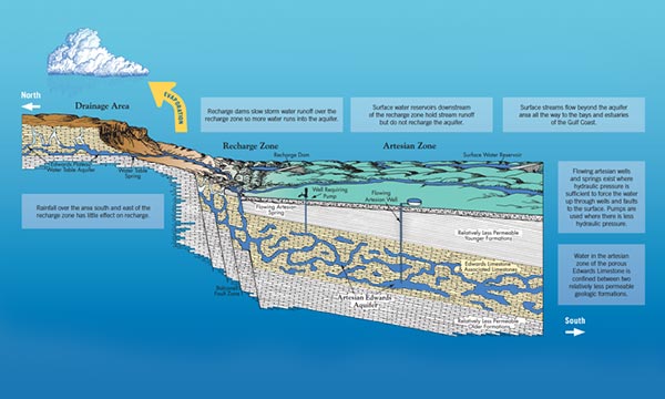
This generalized diagram of a north-south cross section of the Edwards Aquifer region highlights the key components of the aquifer and how they inter-relate and function to form a natural underground system for storing water.
The Edwards Aquifer is a karst aquifer, which means it consists of porous, honeycombed formations of Edwards Limestone and other associated limestones that serve as natural conduits through which water travels and is stored under ground.
Water reaches the aquifer as rain runoff that first collects on the contributing zone (Edwards Plateau), soaks into the water table, and then emerges as spring-fed streams that flow downhill to the recharge zone. In the recharge zone, where the Edwards Limestone is exposed at the land surface, the water actually enters the aquifer through cracks, crevices, caves, and sinkholes, and then percolates further underground into the artesian zone. Here, a complex network of interconnected spaces, varying in size from microscopic pores to open caverns, stores and carries water in a west to east direction. Because water in the artesian zone is under pressure, there are areas where water is forced back to the surface through openings such as springs and free-flowing wells. Where there is not enough artesian pressure to force water to the surface, wells equipped with pumps can extract water from the aquifer for human use.